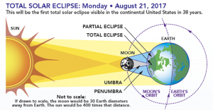
On Monday, August 21, 2017, a total solar eclipse, frequently referred to as the “Great American Eclipse“, was visible within a band across the entire contiguous United States passing from the Pacific to the Atlantic coasts. In other countries, it was visible only as a partial eclipse.
A solar eclipse occurs when the Moon passes between Earth and the Sun, thereby totally or partly obscuring the image of the Sun for a viewer on Earth. A total solar eclipse occurs when the Moon’s apparent diameter is larger than the Sun’s, blocking all direct sunlight, turning day into darkness. Totality occurs in a narrow path across Earth’s surface, with the partial solar eclipse visible over a surrounding region thousands of kilometers wide.
A ground-based image of the total solar eclipse on Aug. 21, 2017 (gray, middle ring), is superimposed over an image of the Sun’s atmosphere, called the corona (red, outermost ring), as seen by ESA (the European Space Agency) and NASA’s Solar and Heliospheric Observatory (SOHO), which watches the Sun from space. At center is an image of the sun’s surface as seen by NASA’s Solar Dynamics Observatory in extreme ultraviolet wavelengths of light.
During a total solar eclipse, ground-based telescopes can observe the lowest part of the solar corona in a way that can’t be done at any other time, as the dim corona is normally obscured by the bright light of the Sun. The structure in the ground-based corona image — defined by giant magnetic fields sweeping out from the Sun’s surface — can clearly be seen extending into the outer image from the space-based telescope. The more scientists understand about the lower corona, the more they can understand what causes the constant outward stream of material called the solar wind, as well as occasional giant eruptions called coronal mass ejections.
The previous time a total solar eclipse was visible across the entire contiguous United States was June 8, 1918; not since the February 1979 eclipse has a total eclipse been visible from anywhere in the mainland United States. The path of totality touched 14 states, and the rest of the U. S. had a partial eclipse.The area of the path of totality was about 16% of the area of the United States,with most of this area over the ocean, not land. The event’s shadow began to cover land on the Oregon coast as a partial eclipse at 4:05 p.m. UTC(9:05 a.m. PDT), with the total eclipse beginning there at 5:16 p.m. UTC (10:16 a.m. PDT); the total eclipse’s land coverage ended along the South Carolina coast at about 6:44 p.m. UTC (2:44 p.m. EDT). Visibility as a partial eclipse in Honolulu, Hawaii began with sunrise at 4:20 p.m. UTC (6:20 a.m. HST) and ended by 5:25 p.m. UTC (7:25 a.m. HST).